Col du Saulude, kinda
July 27, 2000
Distance: 20 km.
Climbing: 841 m.
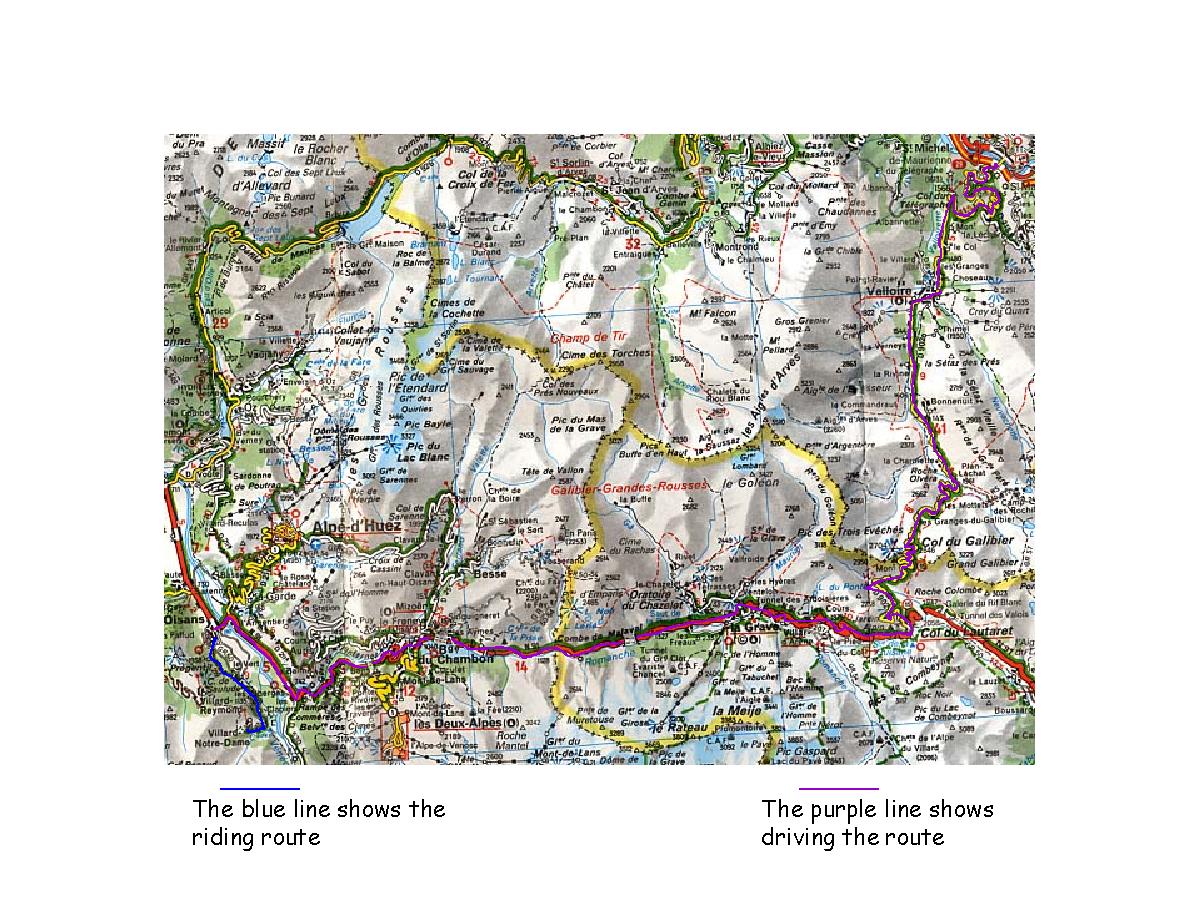
Map (driving and cycling - less detail):
Michelin #244, Rhône-Alpes
Map (cycling only - more detail):
Didier Richard #6, Ecrins Haut-Dauphiné
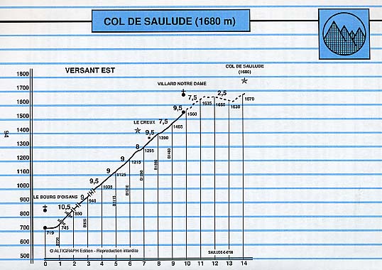
Col du Saulude Profile:
Atlas des Cols des
Alpes, Volume 3, P. 94
Time to say goodbye to St. Michel-de-Maurienne and drive the short distance to the village of Bourg d'Oisans. I packed the car mostly yesterday so, after a quick breakfast I'm ready to roll. M. Barbarot is nice enough to let me send an email to my wife from his computer and I'm off by 8:00 AM.
It was a beautiful day and I was full of anticipation as I pushed the spunky little Renault up the Télégraphe. I'm normally as cautious as a grandmother but I'm feeling frisky today and really getting on it. This little thing pulls so strong you don't even need to shift down to first gear on the switchbacks.
You'll notice that people here seem to drive quickly by American standards which contradicts the common belief that the French don't rush around like the Americans. But you don't have to be here long to figure out that they don't drive fast because they're in a hurry; they drive fast because it's fun. (And in Italy, from what I've seen, they seem to like the fun even more.)
Just before the Col du Télégraphe a road to a village called Valmeinier leaves the main road from the left. I decide to take a side trip just to see. I do this a lot. Sometimes it turns out to be a waste of time. Well, most of the time, but sometimes it turns something up. The road rolls along the side of the mountain with the valley of the Neuvache river below to the left and after a few K's curls around, crosses the river and climbs a little to the small village of Valmeinier. I took this photo near where the road crosses the river. You can see the Fort du Télégraphe on the left. I decide to return to the D902 and the drive up the Galibier rather than pursue this exploration any further.
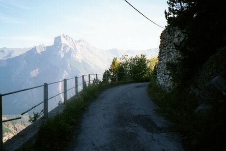
I had been curious to get a close up look at the Fort Du Télégraphe which stands on the side of a cliff about 1 & ½ Km due north from the col. I stop at the Col du Télégraphe summit house and ask the folks if it is possible to go see it. Yes they say and tell me that it's just a short walk down an old military road starting right accross the road from the building. I took the little walk and snapped this photo. Sorry it's so washed out. I'm a terrible photographer. Haven't figured out lighting issues at all. You can sorta get the idea of the scenery though.
So anyway, once I get to the fort I find it closed. On the way back I try to skirt around to the other side on a side trail and this time find myself at the base of the wall at the top of the cliff. Again no way to enter. Oh well. The walk was pleasant enough so the time wasn't entirely wasted. Back to the car to resume the drive up and over the Col du Galibier.
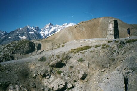
After stopping a few times on the climb to the Col du Galibier to take photos I
reach the top to walk just that bit higher. A little foot path on the west side
of the road leads up a short distance from the parking lot to a small monument
and from here the views are spectacular. (I think the mountain to the left of the
monument is La Meije. If someone knows for sure please
email me.)
There is a large tableau d'orientation that shows which of the distant peaks on the horizon are which. One of them is Mont Blanc and you can just barely make it out in the photo.
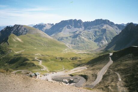
While at the summit I meet some young lads from New Zealanders (Kiwis, they call themselves) on a summer trek around Europe. They all live in the London area and do this in the summers. They are traveling in what appears to be an old delivery truck set up with all the amenties of home - sleeping bags, a fridge and plenty of pin-up posters. We chat and I snap a few more photos and begin the descent down the south side of the Galibier to the Col du Lautaret.
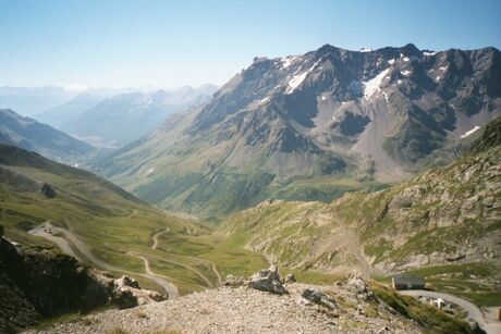
The descent to the Lauteret from the Galibier is only 8 K or so at which point you come to the N91 - the main east-west road that links Grenoble to the west with Briançon and eventually Italy to the east. I turn right, heading west toward Bourg-d'Oisans. From here the grade is still mostly downhill but there's nothing too steep for very long (as I remember) and the road is wide.
Driving this stretch I remember the last time I was here, in 1992. I had been in Bourg d'Oisans and decided to ride to the Col du Galibier from there, coming in the opposite direction that I am going today. Not long out of Bourg d'Oisans I rounded a corner and turned into a tunnel not thinking much of it since I'd never experienced one before. If you've never experienced one of these infernal unlit tunnels you might care to read my ravings about them.
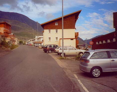
I arrive in Bourg d'Oisans much later than I had planned because of my side-trips and dilly dallying. I'm staying for the next few nights at the Hotel de Milan which is on the left just as you enter the main part of the village. By the time I'm checked in and ready to ride it's 1:30.
The plan today is to take an easy climb up to a village called Villard-Notre-Dame which I'd noticed in one of my day dream sessions staring at the Michelin Yellow #244 map on my wall years back when I had time for such day dreams. The isolated village sits at 1550 meters at the end of the D219 which, according to the map, is likely to be narrow even by European standards.
Past Villard-Notre-Dame I'm not certain of the condition of the road. The Michelin map has it down as a footpath but the IGN Green makes me think it might be ridable. If it is I plan to continue a few K's further to the Col de Saulude and descend down the other side until the pavement starts again at Villard-Reymond and then circle down and back to le Bourg d'Oisans. If the road isn't ridable I'll just ride back down the way I came.
In the parking lot as I'm pumping up my tires I meet a couple of Dutch riders who say they've been up the very same D219 earlier that day. They tell me that they stopped fairly soon into the climb when they reached the second of the four tunnels. They rode in and could see no light at the other end and turned around. They had no lights.
Fortunately I am better prepared. I'd asked around before my trip about this road as I'd noticed from the map that two of the tunnels seemed quite long. One of my cycling acquaintances who knew the tunnels told me that yes indeed they were bad - requiring lights. Heeding the warning and refusing to get off and walk through one more of these infernal things I swallowed my pride in the spring during trip planning and got myself a NiteRider Digital Headtrip light so it was with confidence that I set out that afternoon for an appointment with - tunnel destiny.
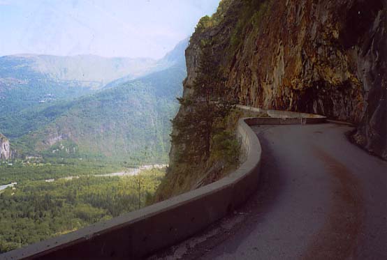
After some more health food (a quick jambon pasterie from an open air bakery) I start off around 1:30. The climb starts immediately on leaving the village. The lower 3 or 4 K of this road is cut into the side of a cliff that runs along this stretch of the Romanche River valley. The grade is pretty steep too and I shift into the 26 in back because I want to save my legs for that "other" climb out of Bourg d'Oisans, which I plan on riding tomorrow. The surface isn't in particularly good shape and is strewn with rocks which have obviously broken off the cliff and tumbled down onto the pavement. Soon into the climb I cross a short, washed out section that is especially bad - but still ridable.
Much of this lower section of the road is cut so deeply into the cliff that the rock forms an arched roof of sorts over the road. (I think this type of road is called a "corniche road"?) The ceiling is dripping and the road is suprisingly wet for a dry day. I wonder if these overhangings are the remnants of former tunnels that have since been blown out by some enterprising French civil engineer with some dynamite and nothing more interesting to do.
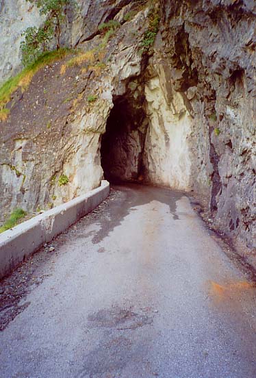
The first of the four tunnels comes very soon into the climb, maybe 1 K, and it's a short one. Not a problem, but I know from my friend's information that the bad ones are yet to come and very soon after comes the mouth of the second tunnel, roughly cut and ominous. I stop to take this photo, flick on the lights and slowly enter the unknown.
As I go deeper into the tunnel the light slowly receeds and within 50 meters or so it is entirely black. The path of the tunnel turns, more than once, making for a long stretch in the middle that's out of sight of either entrance. I stop and turn off my lights just to see if there is a hint of light. Just had to do it. Is it really as dark as it seems? Yes it is. It's as dark as, well I don't know. Think of a really dark place. Let's just say that if I didn't have a light I'd have to walk, feeling along the sides of the tunnel wall. I can see why the Dutch pair I met in the parking lot turned back.
With my trusty NiteRider Digital Headtrip light at full power I am able to ride comfortably at 10 to 15 kph which is just fine. I fully appreciate the helmet mount almost instantly because it allows me to illuminate exactly what I want to. I can see the side of the road, the pavement about to go under my wheels, the hazards a little farther ahead or even my cyclometer. The light from the wide angle bulb tends to diffuse quickly as you try to look farther ahead though. I'd have to guess the spot bulb would work better in this department. But this test was a trial by fire for a bike light and I am very happy with it.
These tunnels sure are fun! The dark isn't the only story though. Water is dripping everywhere, in some places enough to form a steady stream, as from a downspout on the side of a house after a rain storm. I am doused by a couple of these ice cold cascades in the course of traversing this and the three remaining tunnels. It's cool in the tunnels too given that it's 80 something outside. On the plus side the road is actually wider inside the tunnel than it is outside. Go figure. At somehere around 400 m. this tunnel is on the longish side for unlit tunnels too and it seems like it takes a long time to get through it but eventually the exit is in sight and soon I'm out. Success.
As I climb higher there are views across the Romanche valley of a similarly steep mountainside and of a road just like the one I'm on carved into the rock. It's the D211A and I plan on riding there tomorrow. One can also see the villages along the D211 which climbs up to l'Alpe d'Huez.
Although the climbing has been fairly steep up to this point there has not been single switchback or significant change of direction. We're heading pretty much straight south-east climbing up the side of cliff. Two more tunnels pass with one being a bit nasty but not as bad as the second. On exiting the last of the four tunnels there is suddenly fresh pavement and now the riding is smooth albeit still tight due to the very narrow road. But I've only seen one car so far and I'm easily 5 K into it so the width of the road is not much of an issue. (Of course the car's timing could have been better. I heard the all too familiar din of its motor bearing down on me in the last tunnel just as the end was coming into sight. I stepped on it and made it to the end just as the car came by. Yeah. I had a tail light. But I didn't feel like taking any chances.)
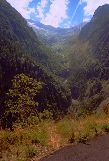
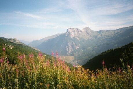
Not long after exiting the last of the tunnels the road comes out from underneath the shadow of the cliff and into the afternoon sunshine as the steepness of the mountainside slackens and the road goes to a switchbacked design. The road slowly curls around to the right making its way in a southerly direction and then after five or six switchbacks it curls again and takes a more westerly path. The remainder of the climb affords beautiful views among which is this mountain flume. It's an absolutely perfect, sunny day and I am treated to views of mountain meadows and distant cascades and almost too soon I come to the isolated hamlet of Villard-Notre-Dame.
I arrive a bit late for lunch but fortunately there is a bar open - a rustic place with a switch under the doormat that makes a lewd sound when stepped on. The proprietress is in the back room with the TV going. She gets up from the task of feeding her son to ask if she can help me. I ask her for a sandwich of "terrine maison". I have no idea what terrine maison is but am feeling adventurous. She prepares it for me, on what seems to be a foot long baguette. I take it out onto the deck behind the dining room and sit down under a sun umbrella at one of the tables. Terrine maison, or at least this terrine maison, appears to be a hybrid of paté and meatloaf. Not so healthy but very tasty. I enjoy it slowly.
I finish and then fill up the bottles at the fountain and follow the sign for the Col du Saulude. As I said earlier the ridability of the road for a non-cyclocrosser on a road bike is unknown to me. Within a stone's throw of the bar the road becomes very rough - like a logging road. I decide not to try to negotiate it and ride back to Bourg d'Oisans the way I came.
I descend back to Bourg d'Oisans and still have time before dinner after I get cleaned up. This is good because now begins the end game for "Operation l'Alpe". I hop in the car for a reconnaissance mission to the mecca of climbing - the 21 switchbacks of the climb to l'Alpe d'Huez. All year I have been planning on a timed assault of l'Alpe. The mission today is to scope out the climb and most importantly the approach to the finish once the road enters the village of l'Alpe d'Huez. However silly it may seem I want to time myself from the bottom to the top and do so all the way to the official Tour de France finish line.
Now I've actually tried this two times before and botched it both times. On a trip in 1989 I made the dreaded wrong turn and ended up coming into l'Alpe d'Huez the back way. In 1992 I rode up the day of the TdF stage (which Andy Hampsten won) and somehow I managed to take the wrong turn again! That time I rode back down to the point of the wrong turn and rode the "right way" up to the village.
This time I am determined not to botch it so I've researched it from home and believe it or not have still been unable to get a 100% certain description from anyone as to the course the road takes through the village and where the TdF stage finish is. The plan today is to drive to the tourist information center in l'Alpe d'Huez and ask them.
As I make my way up the hill the road is quite busy with motorists and cyclists. I'll save the details of the climb itself for tomorrow's writeup since this one has gotten quite long for a day when I only rode 20 K. ;^) Suffice it to say that I give the little Renault another workout on the climb, stop to take pictures here and there and arrive in short order at the village of l'Alpe d'Huez.
The tourist information center sits on the left, up a long flight of steps, just as you enter the first commercial part of the village where the road levels out. I enter and ask the attendant if she knows the finishing route that the Tour de France takes through the village. In a flash she reaches over to a stack of village maps and puts one down on the counter facing me. She's across the counter so the map is upside down from her perspective. She picks up a marker and begins to expertly highlight the course on the street map. Yup. She's done this before. She starts in front of the tourist center and snakes upwards around two more switchbacks, a right hander and finally the sharp left onto the Avenue du Rif Nel and the finish near the northernmost and highest part of the village where she marks the finish line. Very authoritatively done. Perfect. Merci bien.
I pop into the car and take the route she marked all the way to the finish. I know the route is right because I recognize the particular building that appears at the 1 km. to go flag - the site of the Guerini incident. According to her route the finish is on the Avenue du Rif Nel which I also know to be correct. The exact finish would seem to be at the intersection of l'Avenue du Rif Nel and La Rue du Pic Bayle at the Hotel Chaix. At the finish I reset the odometer and on the way back down through the village I make note of how many kilometers to go to the finish at certain points so I'll know for tomorrow. 1 km. to go at the brown and white chalet where the Guerini incident occurred. Around 2 km. to go at the tourist center, 3 km. to go just after switchback #2 and 4 & ½ km. to go in the village of Huez where the D211B breaks off towards Villard-Reculas.
I am back at the Hotel de Milan in time for dinner. Little do I know how interesting tonight's meal will be. For my meal option at the Hotel de Milan (as with the Savoy Hotel in St. Michel-de-Maurienne) I have chosen what is called the demi-pension. This includes a continental breakfast and a full dinner with the price of the room. For dinner one chooses from a limited menu, usually one of two options for each course. From my admittedly scant experience the meals are well prepared by chefs who take pride in their work. The servings are ample too showing that it's OK to expect both good food and ample portions. This stands in contrast to the nouvelle cuisine that you get in most American French restaurants where you see more plate than food.
If the plentiful and tasty French fare that comprises the typical demi-pension at a two star French hotel has a dark side it is that its reputation as being "heavy" is fairly well deserved. And since you're on a limited menu getting something different, like a light and simple meal, can be difficult. Fortunately a new menu option called a "menu sportif" can be found at many French hotels. The idea is to cater more to cyclists and other like minded folks who prefer simpler meals, lower in fat than the normal tasty but heavy French fare. There doesn't seem to be a standard yet and I am not well traveled but it seems that such a menu usually offers at a minimum some sort of simply cooked pasta.
Up to this point I have been happily eating whatever has been put in front of me but tomorrow is truly the big day and I don't want to laden myself down with a heavy meal the night before my TT up l'Alpe d'Huez. Fortunately the Hotel de Milan offers a menu sportif and I do my best to negotiate it with my server. My French is bad and her English isn't any better so we make do and I think I have made my desire for a simple bowl of pasta from the menu sportif clear. However when my meal comes I get the standard plate being served everyone else. Now I have never, ever complained about the food I was brought in a restaurant so I'm not exactly sure why I chose to make a stink at this particular time but I did - just a little stink but a stink nonetheless. I just want to be able to choose a simple bowl of pasta. So I ask the waitress what's wrong as best I can in my French class drop-out French. I thought I ordered the pasta? Blah... Blah.. Blah... Well things get a little tense for a while with folks looking at us from the other tables - very embarrassing. It's an Ugly American scene for sure. But in the end we are able to communicate enough so that I get my pasta and they don't kill me and I think we're all happy.
Well that's it for today. Sort of a lot of text for a little ride. I take a short walk in a light rain in the cool night air in the bustling streets of Bourg d'Oisans and it's time to get to sleep.