l'Alpe d'Huez et. al.
July 28, 2000
Distance: ?? km.
Climbing: ??? m.
Map:
IGN Serie Bleu #3335 ET, Le
Bourg d'Oisans / l'Alpe d'Huez
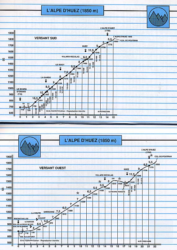
l'Alpe d'Huez Profile:
Atlas des Cols des
Alpes, Volume 3, P. 98
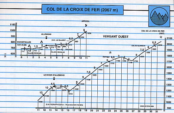
Col de la Croix de Fer Profile:
Atlas des Cols des
Alpes, Volume 3, P. 114
Course Description:
"No Wrong Turns"
The climb to the ski village of l'Alpe d'Huez is a benchmark for climbers and I suppose that for as long as I have known that fact I have wanted to time myself up it. I can't speak to anyone else's reasons for wanting to do this but for me it's simple - to see how I rate against the professionals. Hey, wait a minute. Stop snickering. I'm serious. Now I don't let my mind harbor even the slightest illusions of my own athletic prowess but I deny that such things are simply silly. Sure, if we let such comparisons define too much of our self worth they are silly and even harmful. Sure, comparing oneself to a gifted pro who can train full time for such things but who has also likely ridden two or three other Cols before l'Alpe is an apples and oranges comparison. Granted. But if kept in perspective endeavors like this can still be enlightening. How better to to truly appreciate the natural abilities of the professional cyclist than to lay it on the line and try to do what they have done and see how far we fall from truly being able to do it?
As I said in yesterday's tome I've actually ridden here two times and botched the route both times. Further, the route through the village itself to the TdF finish line is not at all obvious. I hope that those of you who have plans like mine will find this description of the exact course helpful to you so that you don't make the same mistakes I've made. My course description is primarily to tell the reader where the turns are (the ones you might miss, not the switchbacks ;^). I don't try too much to describe the course's difficulty since I am not familiar enough with it to offer anything more useful in those areas than you can get from the Atlas des Cols profile pointed to above.
I will start my personal TT at the banner for the amateur race, "La Montée de l'Alpe", and take splits at the start of the real climb just beyond the Montée start and at the finish line of the amateur race and then continue higher through the village of Alpe d'Huez all the way to the official finish line of the Tour de France stage on the Avenue du Rif Nel. My goal, silly or not, is to ride from the start of the climb to the TdF finish in less than an hour. If I can climb Mt. Washington in 1:11 I should be able to do l'Alpe sub-one-hour. In the perspective department I believe that Marco Pantani rode it in 37 or so minutes.
After I complete the climb to l'Alpe d'Huez I plan on descending back to the hotel and putting my bike back in touring mode then it's back up the D211 towards l'Alpe d'Huez. No I'm not planning to ride the Alpe climb twice. This time I'll take a right turn at la Garde onto the D211A after only a few switchbacks. The D211A is the corniche road that I saw yesterday across the valley while riding to Villard-Notre-Dame. It parallels the N91 and allows one to bypass some of the busy N91's tunnels although the D211A has some itself. However the D211A is much less busy and I'll have my light so the tunnels shouldn't be too bad. The D211A dumps you off on the N91 in the village of le Freney-d'Oisans and there I plan to reluctantly ride the N91 for a few K's (and a few tunnels) until the turn off for the D25 and the climb to the Col de Sarenne which is said to be a very beautiful little climb. From the Col de Sarenne the road continues on to the village of l'Alpe d'Huez and an easy descent back to le Bourg-d'Oisans.
I wake up at 4:15 in the morning and can't get back to sleep. Nerves. It rained on and off last night. The road is still wet and the skies are overcast. It's not raining anymore although it looks like it could go either way. I pass a few hours jotting down notes about yesterday's ride and before long it's time to get dressed up and go down for breakfast.
While eating a light breakfast I have a pleasant conversation with a trio of riders at the next table. One is a butcher, one a court clerk and one a car mechanic. They're biking buddies from a town in Belgium called Wanroy on a 5 day cycling vacation. They ask me what my plan is for today and I tell them that I plan to time myself up l'Alpe d'Huez and then ride the Col de Sarenne loop using the D211A. Bad news. They say they tried the D211A yesterday and had to turn back because a rock slide had blocked the road. Damn. Oh well. I'll decide what to do later.
I finish breakfast and get myself ready for the big effort with a light warmup on the N91 and then and easy climb up the first switchback and back to the start. The weather is looking a little better with some patches of blue sky showing through the grey. Well no point in waiting any longer so I start the chronograph at the Montée start and I'm off.
Although there really is no "easy part" on this climb the first few K's are a bit harder so I'll take it easy (well not too easy) on the lower slopes. I'll make sure to keep up the intensity when I sense the grade ease, no resting, and then turn up the juice progressively as I near the finish. I know myself and I know that I can safely start turning up the juice with around 5 K to go. I also know that, unlike the incredibly long Galibier climb, this climb will not be an endurance test and I won't have to worry about just making it. I have plenty of experience in the hour long climb department and know I can keep up a fairly high pace for that long.
In the first few K's I keep up a healthy pace and yet manage to stay out of the red. At the village of la Garde, which comes after around 3 K of climbing, I'm not overdoing it but I don't allow myself to rest on the easier sections either, shifting up and increasing the speed whenever possible.
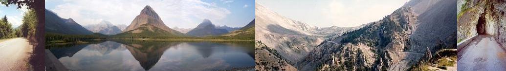
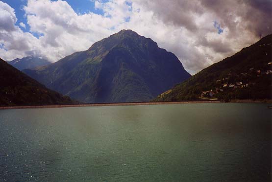
It's clichéed but I honestly can't remember much of the ride itself in this middle stretch from la Garde to Huez. I'm just focusing. Steep parts: keep it outta the red. Easier parts: shift it up and pick up speed. I took this photo yesterday on my reconnaissance mission. I think it's from l'Église St-Férréol. The village in the center is Huez. At the upper left is l'Alpe d'Huez. I'm not absolutely sure but I think the buildings on the upper right that seem higher than l'Alpe are a section of l'Alpe d'Huez called l'Hameau de l'Eclose. This hamlet is at 1830 meters and is slightly lower than the TdF finish in l'Alpe d'Huez which is at 1850. That it seems higher than l'Alpe may be partly due to optical illusion and partly because this picture shows only part of the village of l'Alpe d'Huez.
At 5K to go, in the environs of the village of Huez I click it up a notch. (I can't remember where 5K to go is now but I knew it then and it's somewhere in Huez.) My speedo shows an average speed in the high 14 kph's which is just over 9 mph - on track to get my sub-hour goal but not with much to spare. In the long straight stretch between switchbacks 4 and 3 I avoid making the dreaded wrong turn thanks to my mission yesterday. The wind kicks in here and it's actually enough that I feel it. I crouch over trying to beat it. The wind is not the friend of a rider who is six feet three inches tall and only weighs 150 lbs. Can you say human sail? Well, wind or no wind I'm feeling the effects of the effort by now. You've got enough of the ride behind you and at a good pace too and that in itself makes you hurt. And then you compound it by turning up the juice.

As I approach switchback 2 I see a fellow standing next to a car with fancy camera which he brings to bear on me. I know what's going on having had this same experience on a climb to the Col d'Izoard in 1992. I put on my game face. Yeah. I'm cool. He snaps a few shots as I round the turn.
After switchback 1 there's a steep stretch until the road levels suddenly as you enter the village of l'Alpe d'Huez. On the reconnaissance drive yesterday I paid special attention to this stretch because the course profile called it out and it is near the end where I knew I'd be feeling the effort. This stretch felt steep yesterday in the car but today on the bike I don't feel it that badly, turning the 39 X 24 over nicely. As I enter the town and the road levels I accelerate, in the closest thing that these slow twitch legs have to a sprint, and I pass under the Montée de l'Alpe finish banner taking a split time.
It's only around 9:30 AM but it's already pretty busy with foot traffic and I have to brake to avoid colliding with some folks idling in the street as I make the left turn past the tourist office under the walk way. From here on in it's a near maximal effort. Up the Route de la Poste I ride, imagining I'm Joe Pro on the way to victory not caring that in reality I'd be lucky to climb with the laughing group. I round the last switchback, the one where Pantani was going so fast in 1997 that he almost rode into the crowd as he came out of it. Well, no top chainring for me but I'm turning the 39X13 or 14. Hey I even have to slow for the turn. Yeah!
In no time I'm pushing past the 1 K. to go mark by the two-tone chalet where Guerini was knocked off in 1999. I'm doing the Kraftwerk "Tour de France" breathing for sure. (If I knew how to do it I'd put up a sample of the song. A neat Euro-techno-dance hit from the mid 80's. En danseuse jusqua sommet. Tour de France. Tour de France. Pedaler en grand braquet. Tour de France. Tour de France.)
I make the right turn into the Pl. Jean Moulin but it was an easy one to miss. I'm glad I reconnoitered yesterday. this little stretch of maybe 500 meters is flat and even dips down in a few places and I'm going as fast as I can safely go given that it's an open road and there are rotaries (not on the map). In no time at all I approach the final sharp left turn onto l'Avenue du Rif Nel. It's yet another rotary which I take the wrong way around which is to say I cut to the left directly, the way the racers come in when they finish, rather than going around the rotary. So, sue me. There's tons of visibility and no other vehicles in sight. One final all out sprint to the line at the Rue du Pic Bayle and I stop the clock.
| Section of course | Split |
|---|---|
| La Montée d l'Alpe Start to start of climb |
1:18
|
| Start of climb to La Montée de l'Alpe Finish |
53:16
|
| La Montée de l'Alpe Finish to TdF stage finish on Avenue du Rif Nel |
4:42
|
| La Montée de l'Alpe time |
54:34
|
| "True" climb - (start of climb to TdF stage finish) |
57:58
|
| Start to Finish |
59:16
|
After the effort I poke around the village for a while and buy some souvenirs which I stuff into my pockets and under my jersey. I start the descent back to le Bourg d'Oisans with the feeling of accomplishment that can only come from setting a goal and achieving it stopping at switchback 2 to talk to the photographer, M. Daniel Breton. He gives me his card and tells me the proofs of the photos he took of me should be ready at his shop in l'Alpe d'Huez by around noon time.
I arrive at the hotel after an enjoyable descent under promising skies and put the bike back into touring mode (change to the clincher wheels, put the spare and pump back on, pick up maps, food and camera). Now it's decision time. I have it narrowed down to two choices. The first is to ride the west side of the Col de la Croix de Fer. The second is to climb the Col de Sarenne but ride to the base of the climb entirely on the N91 rather than taking the corniche road, which is unpassable. Although the Col de Sarenne was the orginal plan I just don't feel like dealing with the combination of tunnels and traffic on the N91 and that the Col de la Croix de Fer has been on my to-ride list for a lot longer than the Sarenne so I decide to ride the Col de la Croix de Fer.
After grabbing a quick snack (another cheese-laden sandwich) I pedal north east down the N91 (the tunnel-less part) towards the base of the climb. It's around lunch time but even so the traffic is fairly heavy and of course there are plenty of trucks. Oh well. It's only 7 K and the turn off onto the D526 towards the Croix de Fer. More flat roads and then a hint of some climbing with two switchbacks that scale the side of a large dam called the Barrage de Verney. Then it's a flat road for a bit more as I pass the Lac du Verney and the climb begins at the far end of the lake. Sheesh. It's been essentially 15 flat K from le Bourg d'Oisans to the start of the climb.
This section of the climb is quite persistently steep and unlike many other climbs I've done here is fairly straight with no switchbacks and hardly any significant turns. The road climbs through a heavily wooded narrow valley formed by of the River d'Olle which is on the right. With the land rising close to you on either side there isn't much in the way of scenery here - a definate grunt. It's getting warm and I'm feeling it by the time I arrive at the tiny settlement of le Rivier d'Allemont after a stretch of 2K @ 10%. I stop at a café to refill the water bottles and set out again.
Just after le Rivier d'Allemont the road descends a short steep drop through three or four switchbacks, crosses the river and starts to climb sharply again in the same straight road grunt manner as before. The road has opened up now and is no longer heavily wooded so I get the sense that some scenic views are coming as I climb higher. Unfortunately darkening skies to the northwest have had me concerned since well before le Rivier d'Allemont. As I climb I see the dark clouds coming in more and more and with the weather forecast today for thunder storms I have been thinking about bagging it. I'm a chicken about riding in a thunder storm and don't want to get caught on the top of a mountain pass with no refuge. I climb perhaps another K and decide to abort the mission as the clouds have become noticably darker even since starting the climb after the short descent. Damn.
Feeling a bit silly I turn around and descend a short descent, cross the river and climb the short stretch of switchbacks back to le Rivier d'Allemont. I try not to let my little defeat get to me and concentrate on the descent back to the Lac du Verney which, being steep and fairly straight-ish, is truly a fast one. I'm cautiously riding around 45 kph when I am passed like a human slalom pole by another rider about half way down. I briefly entertain the thought of trying to stay with him and then ask myself, "Why bother?". I'm a god-awful descender really. I certainly don't have the physique for it, or the psyche for it either. "Why risk a crash that could mess up the whole trip?", I think. I always think like that. I let him go. On passing a parking lot at the bottom I see the fellow again. He is already off the bike and has it on the car and is probably getting ready to leave. Ace descender Karol Z strikes again!
The slog back to le Bourg d'Oisans leaves me in a subdued, Charlie Brown-ish sort of mood. Should I have pressed on? Was I being overcautious? Should I have opted for the shorter ride to the Col de Sarenne? Why do the Alps have to pick this summer to be rainy? I put my bike away at the hotel feeling a little sullen but resolve not to let the set back ruin the day. "Hell. You broke the hour for l'Alpe d'Huez this morning." I tell myself. "Snap out of it.". I shower and resolve to take the car around the Col de Sarenne loop before dinner so I can at least see it if not ride it. I'd planned on trying the drive if time permitted after the Croix de Fer and now it was almost essential to rescue the day.
When I get out of the shower I feel vindicated to a degree. It has started raining and I hear the sound of distant thunder. It's over soon and the sun starts to peak out here and there. Well. I guess my descision to turn back wasn't an altogether silly one. Still probably woulda been fine though. Oh well.
I haven't gotten my wife anything yet nor have I picked up the photo that M. Breton had taken of me this morning so I decide to drive up to l'Alpe d'Huez and see if I can finish the business there before things close up for the dinner hour. I'll go that direction to get the business done and then cut around to the Col de Sarenne the back way and come down the way I planned on coming up on my bike.
There are many more cyclists on the road now than this morning when I rode up. It's quite hot now and the riders, most of them anyway, seem to be in difficulty. I can't help but wonder why more folks don't tackle it earlier or later in the day when it's cooler.
I round switchback 2 and there is M. Breton still taking photos.
The folks at M. Breton's photo shop politely show me the photo proofs and I choose one and they tell me to come back in an hour or so and I use the time to shop for my wife. After searching around and dithering about color and size I choose a fleece jacket with a little "Compiegne d'Huez" insignia. At my return to the photo shop the folks are all ready and give me a copy of the photo in a fold-out whiteboard frame with an aerial photo of the switchbacks of l'Alpe d'Huez on the left and my glorious photo on the right. Very nice. I can't remember how much it cost but it wasn't much. Definately worth it if you're there and are lucky enough to ride by when M. Breton has his camera ready.
By the time I'm out of the shop it's getting on to dinner time and I still have my trip to the Col de Sarenne to take so I get to the car and out on the road quickly and am soon out of the busy village and on the much less busy road to the Col de Sarenne. There's actually not much climbing left to get there from this point since it's only a few hundred meters higher than l'Alpe d'Huez. If you look at the profile you'll see a few K of overall downhill going down to 1780 meters and then around 3 K of climbing to the Col at 1989 meters.
The road is obviously not as well maintained as the one to l'Alpe d'Huez and has a definate off the beaten track kind of design - like a logging road that has been paved. (The pavement in this section has a strange redish hue that I've never seen anywhere else. But that's neither here nor there.) There are numerous drainage chutes running across the road in this stretch which make the ride feel a little earthy but, if passed with caution shouldn't present a danger. Imagine a cement pipe cut in half lengthwise and buried into the road perpendicularly with the open side up forming a trough for water to run through. They remind me of the water diverters that you commonly see on hiking trails in New England where they lay a log or two across the trail to force the water to run across the trail rather than down it to help prevent erosion. There is much more water flowing through some of these open culverts than I would have expected at this time of the year. They are kind of deep but not much more than a car tire in width so not there isn't too much potential for damaging a car or bike. Nonetheless I ease the car through them so it doesn't scrape.
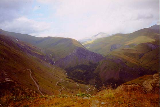
The scenery seems to get better and better. You are on the exposed side of the grassy shoulder of the mountain. Looking back on it now I can't honestly remember the summit of the col itself. It was all beautiful and I stopped many times for photos.

Before the top, the road rides along the grassy mountainside with a river valley to the right far below and a dirt track visible running along it. Another dirt track climbs up from the river through a cleft between two sparse green peaks that frame higher peaks in the distance. Whether it was the cool breeze or the remoteness or the views of mountain peaks extending in layers or the impending sunset or all of the above I can't say but it was serene.1

As I remember it, most of the best scenery was after the summit on the east side. 2 After the col I see a cascade not far from the road at a right hand switchback. A track leads in that direction and I decide to take a look. As I walk to the cascade a small jeep type vehicle with a few young men inside comes ambling by me going toward the cascade. After ten minutes or so of walking I arrive. The picture (like most of my pictures) doesn't do it justice.
I linger for a while and start back to the car. It's chilly now and I'm glad I thought to take the coat I bought for my wife in l'Alpe d'Huez on the walk. Oh she wouldn't mind. On my way out I hear the jeep coming up on me and step off the road as it comes slowly by. I swear I smell a familiar smell wafting by, from my high school days. Party on Didier! Party on François! Back to the car and off.
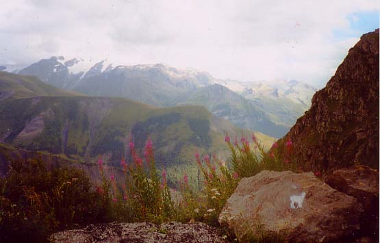
These next two photos were taken on the higher slopes of the east side of the Col de Sarenne. I can't remember where. The scenery was uniformly superlative.
BTW. This first photo captures a plant which may be familiar to my fellow New Englanders as purple loosestrife. This plant is not native to the US and was brought here from elsewhere and has become a universal pest, albeit a beautiful one, forcing out other species of plants and clogging waterways and ponds negatively affecting these ecosystems. Well evidently it is native to Europe and it is all over the place in the French Alps. You may have noticed the same omnipresent purple loosestrife in the photo from Valmeinier on day 3 of the trip.
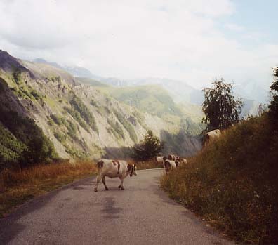
On the descent of the Col de Sarenne I encounter a herd of cows meandering along the road. They are unconcerned by my presence and not in any hurry to move out of my way. Being a neophyte to these sort of encounters I don't know how to approach it. I want to get by but I don't want to cause any problems. Do I honk the horn? Or maybe I could just rev the motor? Instead I opt to drive quietly through. Yeah. I can sneak by on the right. Oh, but no good. A few have shifted to close the gap. They're blocking the entire road now. I keep pace (not hard) with the pack and look for an opening. I'm right in the middle of them now. Cows to the left. Cows to the right. But there's a little break in the middle. I try to squeeze through but they pick up the pace and the gap closes again. This is harder than it looks. I half expect the farmer to come out of nowhere yelling at me to stop scaring his cows. But just as I start to fear that I'll be driving the herd all the way down to the N91 another gap opens and I manage to squeeze past the last of them.
Well soon enough I'm back at the N91 and driving that busy stretch back to le Bourg d'Oisans. Looking back on it I can't even remember if there were any unlit tunnels, the source of my consternation, on this stretch. Oh well. Even now I still regret my choice not to ride this loop but at least now I have something left on my to-do list. Well, because of my failure on the Croix de Fer I still have that one on my to-do list too. I'll do them both the next time I come back here. Hey, I can dream.
I finish out the evening with dinner (no complaints from me tonight. I'm a member of the clean plate club) and a short walk in a light rain afterwards. Then it's packing up for tomorrow when I will be driving to Barcellonette. I try to pack as much as I can the night before to save time on the transport day. This includes packing the bike into the car but now I have one last mundane choice to make tonight. (Leave it to me to make a life's decision out of it.) Do I park in the safe and secure parking lot behind the hotel thus forcing myself to wait until the gate opens at 7:30 tomorrow morning or do I park in the public parking lot adjacent to the hotel so I can get outta here super early and have more time for riding tomorrow? In the end I'm too scared by car theft stories I have heard about Europe and opt for the security of the gated private hotel parking.
1 At home now I see on the map that this track is evidently the Col de Cluy.
2 I'm going on memory now since there is a lapse in my notes.
Dumb things I did today: The fact that I had to make the decision between the Croix de Fer and the Sarenne wasn't my fault and it turned out to be the last ripple effect of the baggage screwup at JFK. Be that at it may I had the choice and I shoulda just gone for the Sarenne ride. That was my plan and that was the reason I brought the light. The ride would have been shorter and I would have been halfway or more up the the col after the 24 K distance at which I turned around this afternoon on the Croix de Fer. Oh well. I am sure glad I drove it and now I have an excuse to come back!